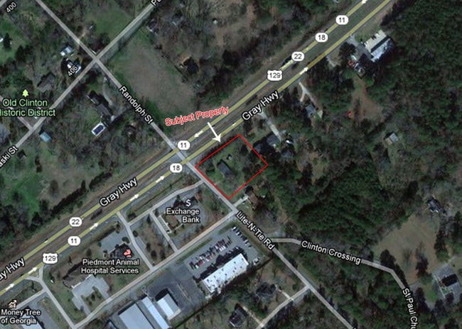
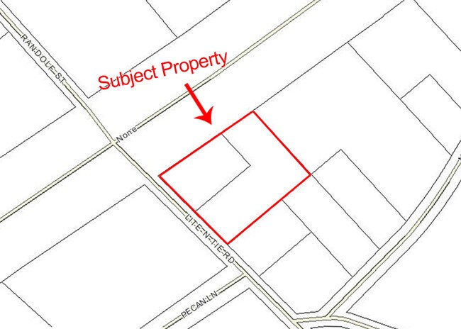
Property Record
105 Lite N Tie Rd, Gray, GA 31032

NEARBY LISTINGS FOR SALE OR LEASE
Property Detail
105 Lite N Tie Rd
Macon-Bibb County, GA
Gray Lots On Hwy 129
G07 00 029
TRACT A HWY 129 DB 1120/571 PB 21/176 LANDLOT: 20 LANDDIST: 9
Restaurantdrivein
Jones
X
Georgia
13169C0235E
1
2024
0.84 AC
2025
Jones County
030305
Atlanta
2,251 SF
DEMOGRAPHICS near 105 Lite N Tie Rd
1 Mile
3 Mile
5 Mile
2024 Total Population
1,609
7,352
11,342
2029 Population
1,621
7,423
11,460
Pop Growth 2024-2029
+ 0.75%
+ 0.97%
+ 1.04%
Average Age
41
40
41
2024 Total Households
635
2,718
4,199
HH Growth 2024-2029
+ 0.79%
+ 0.88%
+ 0.98%
Median Household Inc
$62,692
$70,173
$71,431
Avg Household Size
2.50
2.60
2.60
2024 Avg HH Vehicles
2.00
2.00
2.00
Median Home Value
$204,167
$197,241
$194,201
Median Year Built
2003
1999
1995
Nearby Places
Map Layers
Map Styles
 Street
 Aerial
- Restaurants
- Banks
- Shops
- Fitness
- Groceries
SALE & LEASE HISTORY
LISTING DATE
SALE/LEASE

Sep 24, 2016
For Sale
Mar 15, 2017
For Sale
Nearby Properties
Address
Land Use
TOTAL SIZE
Lot Size
Zoning
Address
Land Use
TOTAL SIZE
Lot Size
Zoning
Address
Land Use
TOTAL SIZE
Lot Size
Zoning
149,721 SF
67.25 AC
001
Address
Land Use
TOTAL SIZE
Lot Size
Zoning
46,007 SF
10.23 AC
Address
Land Use
TOTAL SIZE
Lot Size
Zoning
6,540 SF
9.80 AC
001
Address
Land Use
TOTAL SIZE
Lot Size
Zoning
81,736 SF
46.81 AC
004
Address
Land Use
TOTAL SIZE
Lot Size
Zoning
107,652 SF
40.27 AC
001
Address
Land Use
TOTAL SIZE
Lot Size
Zoning
87,464 SF
50 AC
001
Address
Land Use
TOTAL SIZE
Lot Size
Zoning
53,365 SF
9.19 AC
002
Address
Land Use
TOTAL SIZE
Lot Size
Zoning
21,930 SF
3.02 AC
004
Address
Land Use
TOTAL SIZE
Lot Size
Zoning
2,508 SF
4.43 AC
004
Address
Land Use
TOTAL SIZE
Lot Size
Zoning
28,280 SF
29.26 AC
004
Address
Land Use
TOTAL SIZE
Lot Size
Zoning
4,184 SF
7.94 AC
001
Address
Land Use
TOTAL SIZE
Lot Size
Zoning
54,374 SF
7.33 AC
001
Address
Land Use
TOTAL SIZE
Lot Size
Zoning
49,837 SF
7.92 AC
002
Address
Land Use
TOTAL SIZE
Lot Size
Zoning
3,360 SF
1.64 AC
Address
Land Use
TOTAL SIZE
Lot Size
Zoning
38,260 SF
14.67 AC
Address
Land Use
TOTAL SIZE
Lot Size
Zoning
11,611 SF
2.50 AC
004
Address
Land Use
TOTAL SIZE
Lot Size
Zoning
14,859 SF
0.72 AC
002
Address
Land Use
TOTAL SIZE
Lot Size
Zoning
2,620 SF
29.94 AC
004
Address
Land Use
TOTAL SIZE
Lot Size
Zoning
25,400 SF
2.13 AC
002
Address
Land Use
TOTAL SIZE
Lot Size
Zoning
3,488 SF
12.44 AC
002
Address
Land Use
TOTAL SIZE
Lot Size
Zoning
8,608 SF
2.40 AC
Address
Land Use
TOTAL SIZE
Lot Size
Zoning
24,766 SF
11.68 AC
001
Address
Land Use
TOTAL SIZE
Lot Size
Zoning
2,160 SF
12.28 AC
002
Address
Land Use
TOTAL SIZE
Lot Size
Zoning
44,850 SF
1.32 AC
001
Address
Land Use
TOTAL SIZE
Lot Size
Zoning
8,972 SF
2 AC
002
Address
Land Use
TOTAL SIZE
Lot Size
Zoning
6,620 SF
11.58 AC
001
Address
Land Use
TOTAL SIZE
Lot Size
Zoning
25,674 SF
2.22 AC
002
Address
Land Use
TOTAL SIZE
Lot Size
Zoning
3,460 SF
1.30 AC
001
Address
Land Use
TOTAL SIZE
Lot Size
Zoning
34,473 SF
3.42 AC
002
The World's #1 Commercial Real Estate Marketplace
Connect with us
© 2026 CoStar Group
The information above has been obtained from sources believed reliable. While we do not doubt its accuracy we have not verified it and make no guarantee, warranty or representation about it. It is your responsibility to independently confirm its accuracy and completeness. Any projections, opinions, assumptions, or estimates used are for example only and do not represent the current or future performance of the property. The value of this transaction to you depends on tax and other factors which should be evaluated by your tax, financial, and legal advisors. You and your advisors should conduct a careful, independent investigation of the property to determine to your satisfaction the suitability of the property for your needs.